| Table of Contents | ||
|---|---|---|
|
Creating a Geospatial File 

| To create a new information resource, you can use the "Upload" button on the tDAR toolbar (You are able to access this toolbar and button on any page within tDAR). You must first create a new information resource to ingest a geospatial file into tDAR. |
|
| You will then be presented with a screen that asks you to select the resource type you wish to add. Choose "Geospatial" from the options presented. | 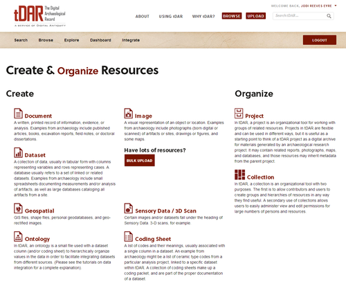 |
| Info | ||
|---|---|---|
| ||
You will have to be registered and logged into tDAR before uploading a new resource (see /wiki/spaces/TDAR/pages/557080). |
| Tip | ||
|---|---|---|
| ||
If so, you may want to also view the tutorials on Organizing Your Data. |
| Info | ||
|---|---|---|
| ||
To create a digital resource in tDAR, you will complete two steps:
|
Entering Metadata for Your Resource
Basic Information | |||||||||||||||||||||
|---|---|---|---|---|---|---|---|---|---|---|---|---|---|---|---|---|---|---|---|---|---|
Status (required) | In the "Status" field, select the status that describes the state of this information resource. When first creating a file, you will likely choose between:
OR
There are two other statuses available:
| ||||||||||||||||||||
Title (required) | Title of the file | ||||||||||||||||||||
Year (required) | The "Year" field documents the year in which the file was created and/or "published" in its current state. Use the textbox to enter the year the file(s) you are uploading was created. | ||||||||||||||||||||
Currentness & Update Information (required) | Describe how current the file(s) being uploaded are. | ||||||||||||||||||||
Spatial Reference System & Projection (required) | Enter the spacial reference system and/or the projection data for the geospatial files (ex: EPSG: 3857). | ||||||||||||||||||||
Map Source | Describe the source of the map. Include a citation, if possible. | ||||||||||||||||||||
Scale | Provide the scale for the map (ex: 1:1600). | ||||||||||||||||||||
| Info | ||
|---|---|---|
| ||
You can come back at a later time and edit the metadata for a resource, as can anyone who has access to edit the resource (see Access Rights in tDAR). |
| Info | ||
|---|---|---|
| ||
You may want to put when the original map was produced, when the image was geo-rectified or how often this file will be updated. Any information that will help other researchers know whether the file is current and up to date. this is a required field. |
Choose an account to bill from | |
|---|---|
If you only have one billing account, this account will already be selected. | 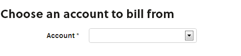 |
| It you have access to more than one billing account, elect the drop down menu for "Account". A list of Billing Accounts that you have access will be visible. Select which account you would like to use the fund from to pay for this resource. | |
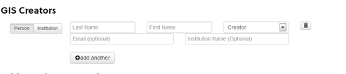
GIS Creators | |
|---|---|
| Begin entering the name of a creator in one of the name fields in the "Person" data entry section. tDAR will make suggestions from a list of tDAR users and other entered persons (i.e., other creators, authors, editors, etc.). |
|
If one of the suggested persons matches the person you wish to identify as a creator, select that person. If the suggested persons do not include the person you want to identify, then enter that person's name, email address, and institutional affiliation as accurately as possible. Enter a current email address and institutional affiliation ONLY if you are confident it is accurate. | |
| To add additional creators, click on the "add another" button. Enter the appropriate information for that person and select the appropriate role. | |
| In some cases, an individual person may not be credited with creation. Rather, an institution may be identified as creator. To add an institution as a creator, click on the "add another" button and select "Institution". | 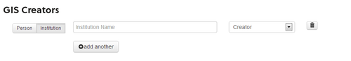 |
| Info | ||
|---|---|---|
| ||
The "GIS Creator" data entry section asks you to list the persons who contributed to the construction of the file you are uploading to tDAR. A person who contributed to the creation of the file may have originally created the map or images or created the GIS files. Other contributors can be listed under Individual and Institutional Roles |
Additional Citation Information | |
|---|---|
| If the resource you are uploading to tDAR has been published else where, include that information in the "Additional Citation Information" fields. | 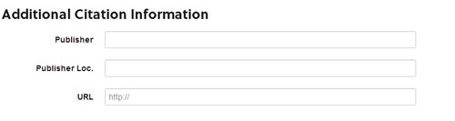 |
PublisherIn the "publisher" field, enter the publisher of the document that you are uploading to tDAR. | |
Publisher Loc(ation)City where the publisher is located | |
URLIf this resource is published online, enter the URL | |
Abstract / Description | |
|---|---|
| This text field allows you to provide a narrative about the content of the document. | 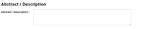 |
Attach GIS Files | ||||||
|---|---|---|---|---|---|---|
Click on the "Add files" button to open up a file window.Select all the files required for your GIS resource, and choose "Open". More than one file can be uploaded at once, and up to 50 files can be uploaded for each GIS resource. If you receive an error, make sure you are uploading the accepted file types.
| 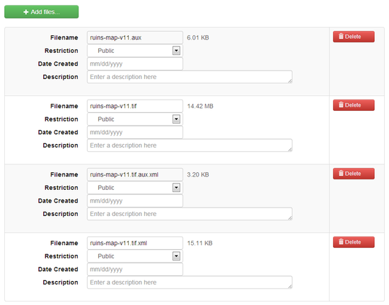 | |||||
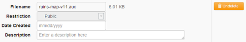
To delete a file, select the "Delete" button to the right of the file you want to delete. If you accidentally delete a file, don't worry: an "Undelete" button will appear next to a deleted file.
| ||||||
RestrictionThe default restriction is "Public". Public files are accessible to all registered tDAR users. Select the drop-down box to change the restrictions to "Embargoed" or "Confidential". | ||||||
Date CreatedThe date this specific file was created. | ||||||
DescriptionAdditional information specific to this file. | ||||||
| Note | ||
|---|---|---|
| ||
tDAR provides two different ways to restrict access to files you upload to tDAR:
To permit other registered tDAR users to download confidential/embargoed files, you must enter their names into the "Access Rights" fields at the bottom of the metadata entry page. You can grant ONLY registered tDAR users the access rights to download these files.
For further information on marking a resource as confidential or placing an embargo, see Managing Security and Access. |
tDAR Collections & Project | |
|---|---|
Add to a Collection (or Collections)Here you may enter the name of the collection that this document is associated with. As you enter the name of the Collection, choices will appear in the drop-down box, select the appropriate Collection See Creating or Editing Collections to learn more about how collections are useful in organizing and displaying your resources. |  |
Choose a ProjectIn the "Project" field, use the drop-down box to select the project with which the file is associated. If you used the project toolbar "add new resource to project" button to create the file, the project is already selected for you (see description of creating a file above). If your document is not associated with a project, select "No Associated Project" from the drop-down menu. tDAR will associate your document with your personal information resources. | 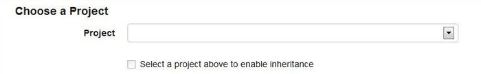 |
| Tip | ||
|---|---|---|
| ||
When you associate a document with a project, you are accomplishing two things in tDAR:
Inheriting ValuestDAR allows you to "inherit" the metadata that you entered at the project level to describe the documents or other resources associated with that project. Inheriting metadata from the project to the document helps you to simplify your data entry. You will see a checkbox labeled "Inherit values from parent project" in many of the data entry sections on the document page (and on other resource entry pages). Use this checkbox to inherit the relevant values from the associated project to the individual resource. To "inherit" values from the parent project to the document here, check the box labeled "Inherit values from parent project". What if I change the values in my project?If you change any metadata values at the project level, tDAR will update those "inherited" values at the resource level. For example, if you change "Investigation Types" for your project, any resource that inherited "Investigation Types" from that project will be automatically updated. What if I only want to inherit "some" of the values in my project?You can inherit values by clicking on the "inherit values..." box, and then un-select the box to make additional changes that are particular to that resource. For example, you can inherit the spatial information from a project to a related resource. You can then un-select the "inherit values..." box to add or subtract location keyword terms particular to that individual resource. You can also use the project as a template for your resource entry. You can simply enable inheritance to "copy" the values from the project, and then turn inheritance off to make specific changes. For more information on inheritance, please see the section "Inheriting Project Metadata" on the "Creating or Editing a Project" page. |
| Include Page | ||||
|---|---|---|---|---|
|